Current Projects
This is the list and short description of current projects with IMPC involvement.
SWESNET

The ESA Space Safety Programme actively addresses user communities that are sensitive to space weather, such as spacecraft operations, power systems operations or airlines. Targeted service developments aim to address the needs of these groups for accurate and timely space weather information. The ESA SWE Service Portal provides access to a total of 29 user-tailored services that build on more than 300 individual products and tools!
Each space weather service comprises a tailored selection of products, tools, alerts combined with user support and guidance. Although many of the products can be used independently - bringing them together and grouping into user driven services provides a complete picture of ongoing and upcoming space weather conditions tailored towards the needs of a given user group.
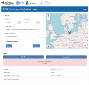
DLR is coordinating the Ionospheric Weather ESC (I-ESC). The mission of the of the I-ESC is to is to provide and develop the functionalities, capabilities and expertise in the domain of Ionosphere and upper Atmosphere that are needed within the ESA SWE network to achieve as a collaborative enterprise its mission of demonstrating and assessing the influences of Space Weather and informing and supporting end users through the provision of accurate, reliable and timely products and (pre-)operational services, tailored to their requirements. The I-ESC thus provides, implements and supports the Ionospheric and upper Atmosphere Weather products and capabilities of the ESA SWE network, including the observation, monitoring, interpretation, modelling and forecasting of Ionospheric and upper Atmosphere Weather conditions. In this framework, the IMPC develops and provides ionospheric key products e.g. TEC maps, ROTI maps, scintillation indices S4 and sigma phi, time series of slab thickness and MUF750 alarms as well as GNSS performance indicators tailored to the needs of GNSS users.
More information:
PECASUS for ICAO

The PECASUS consortium is one of the four global centers providing space weather advisories according to ICAO regulations. These advisories are sent to airliners using the existing aeronautical fixed network for international aviation (AFS).
IMPC services are an integral part of the PECASUS consortium, which operates one of the four ICAO global space weather centers since Nov 7, 2019. Information about current space weather advisories are available from the Civil Aviation Weather Service by the Finnish Meteorological Institute. The consortium is led by the Finnish Meteorological Institute (FMI) and advises pilots in the event that space weather (SWX) has moderate or severe effects on flight-level radiation, satellite navigation or long-range radio communications. DLR leads the developments in the GNSS domain in strong collaboration with other European institutions providing space weather data, such as INGV, SRC, STCE and FMI.
More information:
H037-MoNEWIC

Launched by ESA in 2010 as part of the European GNSS Evolution programme, the Monitor project aimed in its first phase (2010-2013) to improve our knowledge of ionospheric variability and signal scintillation through the development and deployment of innovative techniques. While in the second phase (2014-2016), an extensive network of globally distributed receivers was established to analyse both, total electron content (TEC) and scintillation data. Particular attention was paid to extreme scintillation events. While this remains an important part of the new eMONITOR requirements, additional emphasis was placed on monitoring the so-called Evil Wave Form (EWF), as technical distortions of GNSS signals are particularly important for Safety-of-Life applications.
Within the framework of the ongoing H2020 project H037-MoNEWIC, these tasks are currently being worked on by DLR together with NLR, ADS, IEEA, UPC and ICTP. Furthermore, an attempt is being made to record bitgrabber data streams of heavy scintillation events from low and high latitude regions. Such data streams can then be used as example scenarios for different GNSS receivers to test their robustness to strong phase and amplitude scintillations. For this activity, two bitgrabber recorders will be placed at low latitudes in African countries (Nigeria and Rwanda) and one at high latitudes in Scandinavia (Norway). In combination with other installed GNSS and EWF receivers, they will form the GNSS experimental receiver network within the EGNOS extension area.
More information:
ISES

In April 2023 the DLR Institute for Solar-Terrestrial Physics joined the International Space Environment Service (ISES) which aims to:
- Provide real-time forecasting and monitoring of space weather to reduce and mitigate the risk of space weather impacts on technology, critical infrastructure, and human activities.
- Facilitate international communication and service coordination regarding space weather, particularly during periods of enhanced activity and in the event of extreme space weather.
- Improve space weather services and promote the understanding of space weather and its effect for users, researchers, the media, and the general public.
As a Collaborative Expert Center (CEC) DLR will encourage and support the development of space weather services and to contribute expertise in space weather forecasts, watches, warnings and alerts.
More information:
P3-SWE-XLII: Space Weather Impact on GNSS Performance Application Development (SWIGPAD)

Under the ESA Space Safety Programme (S2P), a system to monitor, predict and disseminate SWE information and alerts is being developed. Precursor Space Weather services were initiated during the ESA Space Situal Awareness Programme (SSA) (2009-2019). The ESA SWE services are provided as a federated system operated by multiple European research institutes organized under five Expert Service Centers (ESCs). The development of this application was executed and managed within the activity P3-SWE-XLII: Space Weather Impact on GNSS Performance Application Development (SWIGPAD). It is integrated into the activities of the Ionospheric Weather ESC (I-ESC) which is currently coordinated by the German Aerospace Center (DLR).
More information:
MIGRAS

Precision and safety of life applications using trans-ionospheric signals require key information on space weather conditions in particular on the perturbation degree of the ionosphere. Such systems are particularly vulnerable against severe spatial gradients and rapid changes of the electron density (Ne) as well as the total electron content (TEC) measured along different satellite‐receiver links.
Two new Swarm products are proposed:
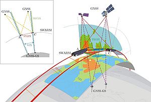
- TEC Gradient Ionosphere indeX (TEGIX)
- Ne Gradient Ionosphere indeX (NEGIX)
The TEGIX measures spatial TEC gradients in the topside ionosphere (Swarm up to GNSS orbit) using GNSS Precise Orbit Determination (POD) measurements, whereas the NEGIX measures the spatial Ne gradients using Swarm onboard Langmuir probe (LP) measurements (using 2 Hz data).
The approach takes benefit from the coordinated flight of satellites A and C at an orbit height of about 460 km.
A first iteration of a prototype demonstrator is proposed for TEGIX and NEGIX generation and samples case studies to explore their potential impact, utility and usage. A comprehensive validation study is outlined for TEGIX and NEGIX products.
Gradient Ionosphere indeX (GIX) estimated from ground GNSS observations will be compared with TEGIX and NEGIX. Swarm 16 Hz density estimates, available as an advanced product and known to be relatively stable and unbiased, will serve as a reference for a relative scaling A<-->C of the LP 2 Hz density measurements.
Project duration: October 2022 – November 2023. This project is funded by ESA via the Swarm DISC, Sub-Contract No. SW‐CO‐DTU‐GS‐133.
More information:
PITHIA-NRF

PITHIA-NRF seeks to establish a European distributed network that integrates various research infrastructures dedicated to ionosphere, thermosphere, and plasmasphere research. It enables European researchers to access key national and regional facilities, such as EISCAT, LOFAR, Ionosondes, and others, fostering optimal utilization and collaborative development. The project aims to provide organized access to experimental facilities, FAIR data, standardized products, training, and innovation services. By integrating data from satellite missions and prediction models, PITHIA-NRF aims to advance research in the upper atmosphere and near-Earth space. Additionally, the project promotes the development of observing technologies and standards for software and high-level data products. Through the Trans-National Access program, PITHIA-NRF facilitates effective access for external research teams to utilize its nodes and learn to work with the facilities throughout the entire research cycle.
More information:
https://pithia-nrf.eu/pithia-nrf-users/tna/nodes/dlr-so-node-1
https://pithia-nrf.eu/pithia-nrf-users/tna/evaluation-criteria-and-advice-for-applicants
HiGAIN

The project HiGAIN is concerned with the development of advanced technologies and algorithms that can support the goal of high-precision and highly integrated satellite navigation and high-precision indoor navigation.
Mobility applications such as air cabs, autonomous drones and cars, ships (especially in ports), and trains require accurate and reliable navigation solutions to safely shape the future of transportation on land, sea, and air. In order to achieve the positioning and navigation requirements demanded by the various user groups in terms of their performance, availability and reliability (especially integrity), difficult technical challenges have to be overcome due to the very challenging environments in which accurate and reliable positioning is required. For example, poor visibility and shadowing of GNSS satellites in street canyons and tunnels, as well as radio frequency interference and multipath propagation of GNSS signals in urban environments, require navigation solution concepts that go beyond standard GNSS solutions.
More information:
https://www.dlr.de/kn/en/desktopdefault.aspx/tabid-2081/6941_read-86762/
GNSS Performance Monitoring

GNSS Performance Monitoring is a unique DLR tool developed by DLR's Galileo Competence Center comparing internationally available satellite navigation system data (Galileo - EU, GPS - USA, GLONASS - Russia, BeiDou - China) in a consistent manner by using the same high-performance antennas, receiver networks and analysis algorithms for each system. Real-time data, as well as long term archived data, are or will be used for visualization and computation of performance parameters.
The purpose of this project is to monitor the reliability and quality of navigation signals, to detect errors promptly and to disseminate this information to applications. A system will therefore be set up to monitor satellite signals, detect deviations from the nominal state of navigation systems, analyse those deviations and, if necessary, distribute warnings. This work will primarily focus on supporting the development and establishment of the European navigation system Galileo but will, in a second phase, also be capable of analysing the already established systems GPS, GLONASS and BeiDou/BDS.
More information:
https://gnss-monitoring.dlr.de/
https://www.dlr.de/gk/en/desktopdefault.aspx/tabid-17187/27201_read-69520/
