GNSS based TEC
In a first approximation the ionospheric range error in GNSS is proportional to Total Electron Content (TEC). This is the reason why TEC is the key parameter for characterising the ionospheric impact on GNSS. The advantage of TEC, which can be derived from GNSS measurements, is the good global data coverage, compared to other ionospheric measurements.
TEC is defined as the integral of the electron density along the ray path between satellite and receiver. Thus, TEC provides the number of electrons per square meter. The most frequently used unit is 1TECU = 1x10¹⁶ electrons / m2.
Provision of GNSS based TEC data for AFFECTS
TEC maps over Europe and global TEC maps are routinely produced by the SWACI service of DLR and provided for the AFFECTS project. After generation the data is directly usable in the FSI and transferred to this website for provision to the AFFECTS consortium members and registered users.
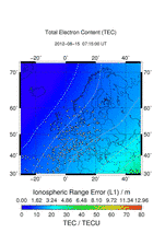
24 hours TEC forecast maps for Europe TEC for Europe
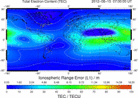
Near real time global TEC maps
Quality check with NOAA CTIPe results TEC Global
Use of GNSS based TEC data in AFFECTS
TEC Europe
Description of application | Beneficiary | Data access |
Preliminary analyses for developing the early warning message for GNSS users | DLR | FSI |
Validation of Early Warning for GNSS | DLR | FSI |
Development of perturbation TEC model | DLR | FSI |
Provision of Slab Thickness | DLR | FSI |
Correlation of dTEC with solar parameters and geomagnetic indices | DLR | FSI |
Comparison with solar wind and IMF variations and polar electro jet movements | UGOE | online |
TEC Global
Description of application | Beneficiary | Data access |
Validation of CTIPe TEC maps | NOAA-SWPC | FSI |