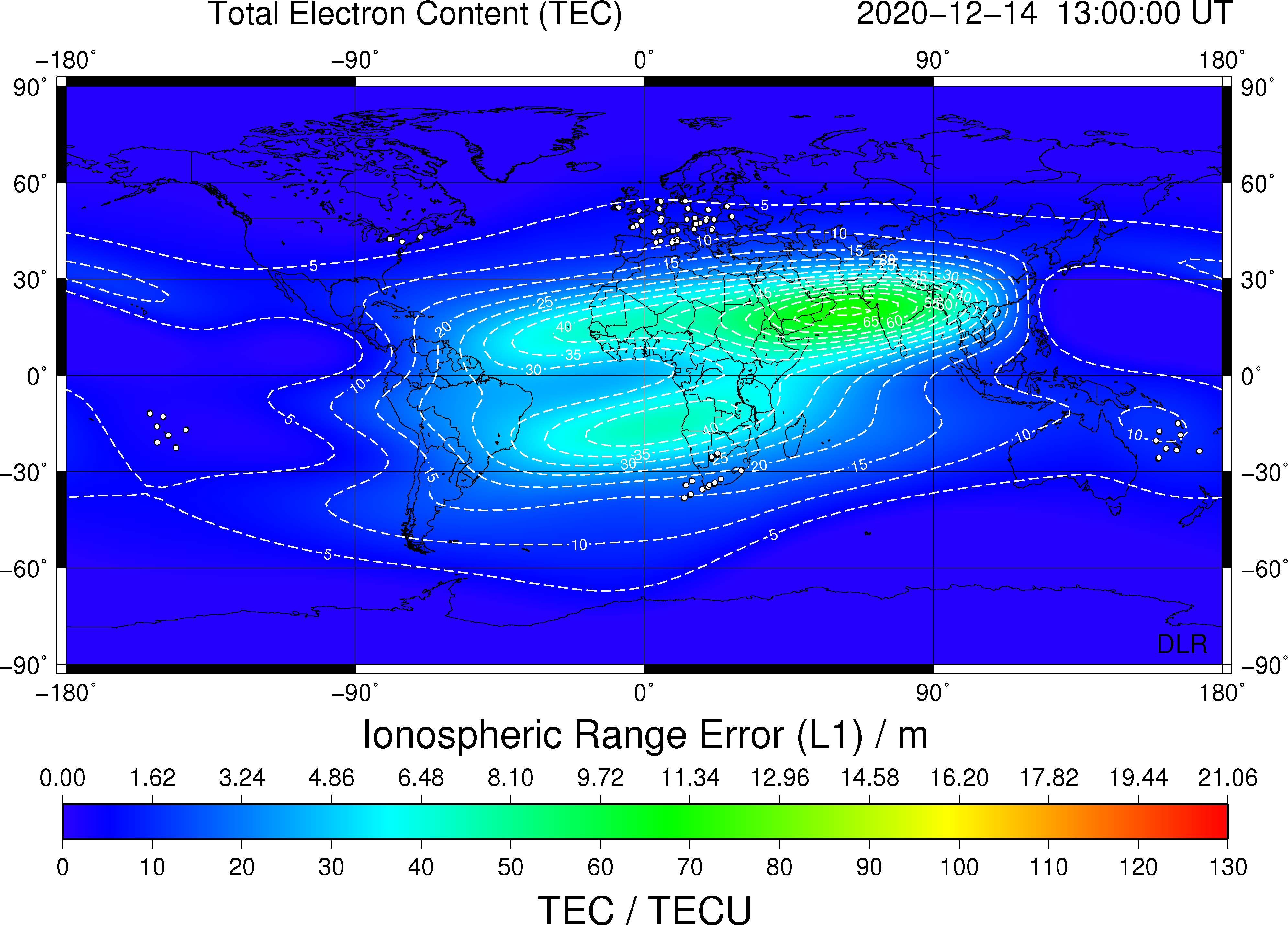
TEC Global Observation (DLR)
Global TEC maps are provided to AFFECTS by DLR via the SWACI service every hour. TEC derived from numerous groundbased GNSS measurements is assimilated into an empirical TEC model.
- Jakowski N. (1996) TEC monitoring by using satellite positioning systems. In: Kohl H., Ruester R., Schlegel K. (eds) Modern ionospheric science. EGS, Katlenburg-Lindau, ProduServ GmbH Verlagsservice, Berlin, pp. 371-390
- Jakowski et al.: Operational space weather service for GNSS precise positioning, Ann. Geophys., (2005), 23, 3071-3079, doi:10.5194/angeo-23-3071-2005
- Jakowski et al.: Total electron content models and their use in ionosphere monitoring, Radio Sci. (2011) 46:RS0D18, doi: 10.1029/2010RS004620 )
- Jakowski et al., A new global TEC model for estimating transionospheric radio wave propagation errors, J Geod (2011) 85:965-974, doi: 10.1007/s00190-011-0455-1).
This is a plot of TEC.
TEC Global CTIPe-Model (NOAA)
The Coupled Thermosphere Ionosphere Plasmasphere Electrodynamics Model (CTIPe) is a state of the art research tool used at the Space Weather Prediction Center to study thermosphere-ionosphere phenomena in order to develop nowcasting and forcasting algorithms for space weather. The objectives are to understand and quantify the importance of the upper-atmospheric mechanisms that affect human activities and to develop new monitoring and predicting techniques.
This is a plot of TEC from the Real Time Run of CTIPe (http://helios.swpc.noaa.gov/ctipe/TEC.html).

CTIPe TEC - TEC Observation
CTIPe Comparison with DLR global TEC maps is computed and provided by NOAA (http://helios.swpc.noaa.gov/ctipe/Valid_TEC_DLR.html).
This is a comparison of the near-real-time TEC plots produced by the CTIPe model and DLR assimilation data. The plot shows the differences between the CTIPe model and the DLR model.

Please use the login to see more information und products.