One minute maximum ROTI, Europe
Maximum ROTI is presented for the preceding minute for the European region.
Latest Data
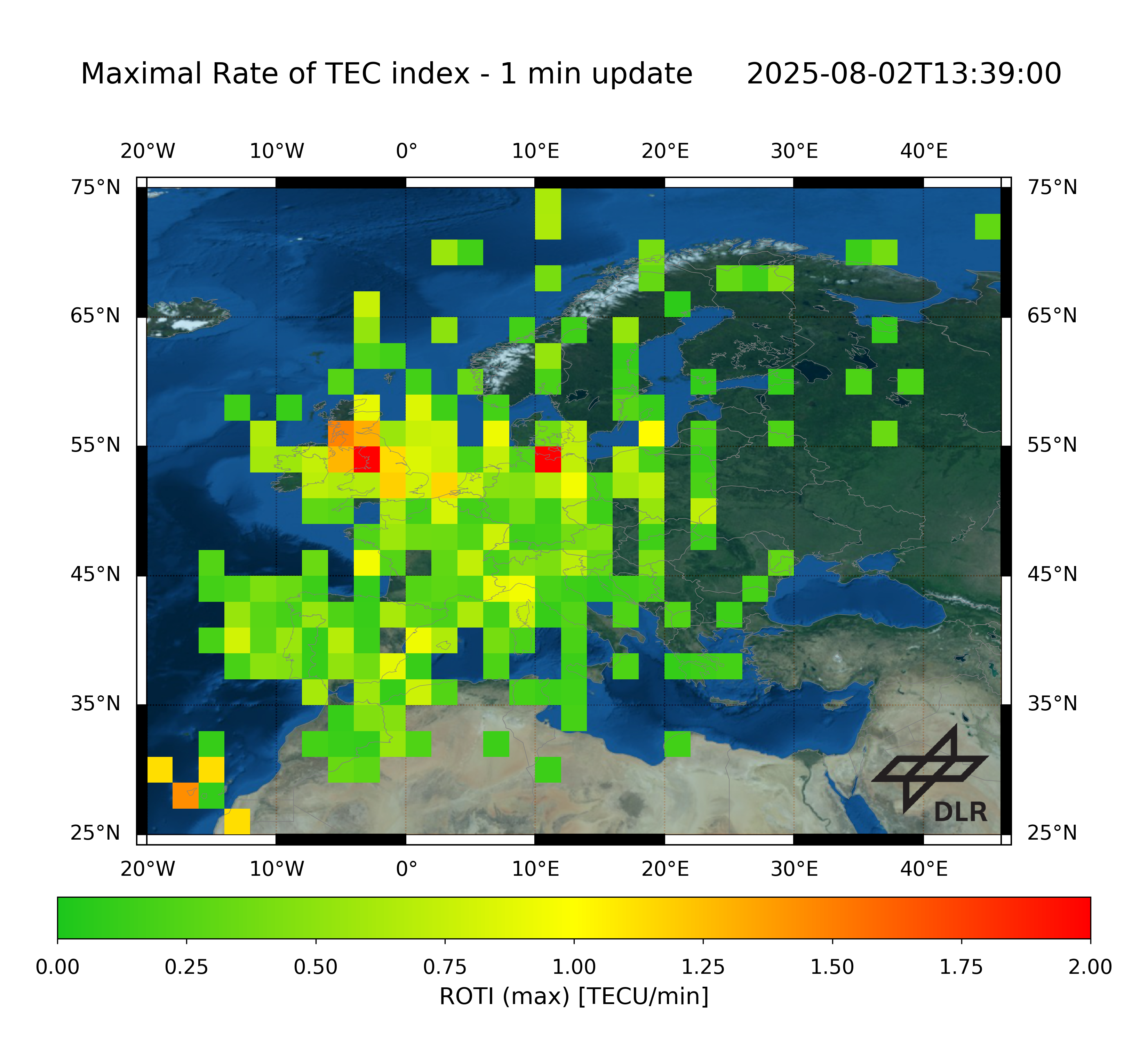
The Rate of TEC index (ROTI) is defined as standard deviation of the rate of TEC (ROT) assuming the ionosphere as a thin layer. Hence the index provides information about temporal ionospheric irregularities. DLR’s ROTI is calculated for the European region between 25°N – 75°N and 20°W – 45°E. As input GPS dual-frequency data is acquired from different providers, like IGS and EUREF, in real-time via the German Federal Agency for Cartography and Geodesy in Frankfurt. These data is used to calculate relative TEC as input for the ROTI processing. The standard deviation is calculated over a one minute window and the ROT is calculated each second.
The ROTI measurements are mapped into a regular grid (2°x2° lat/lon). Each grid cell presents the mean of the ROTI measurements located in this cell.
Product Specification
| Specification | Description |
|---|---|
| External parties | German Federal Agency for Cartography and Geodesy |
| Data providers | IGS, EUREF, ASI, Greenland network of the Technical University of Denmark |
| Input data | GPS dual-frequency measurements |
| Input sampling rates | 1s |
| Reliability of data source | Data is preprocessed by DLR including e.g. cycle slip detection |
| Region of sensors | Europe |
| Sensors | cf. station list |
| Single-layer shell height | 400 km |
| Spatial resolution | 2° x 2° latitude-longitude-bins stations |
| Boundaries of grid | 25 – 75°N, 20°W – 45°E |
| Temporal resolution | 15 min |
| Time information | UTC Time |
| Reference coordinate system | ECEF coordinate system with WGS84 reference ellipsoid |
| Algorithms | The rate of TEC (ROT) is calculated receiver-satellite-link specific with a time difference that corresponds to the usual sampling rate of 1 Hz. Based on the ROT the ROTI is calculated over a sliding window of one minute. Afterwards the available ROTI values are binned in 2°x2° bins and averaged. The minimum number of samples within one bin equals one. |
| File format | ASCII |
| ASCII file format | JSON: this file format includes metadata and data; the meta data key “data” provides a data matrix of ROTI values where the first row represents all ROTI values between 20°W-45°E for a latitude of 25°N |