TEC Gradient Ionosphere indeX (TEGIX)
The TEGIX measures spatial TEC gradients in the topside ionosphere (Swarm up to GNSS orbit) using GNSS Precise Orbit Determination (POD) measurements using Swarm onboard Langmuir probe (LP) measurements (using 2 Hz data).
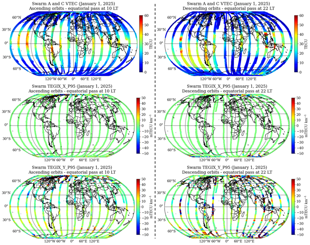
Sample Data
Global Swarm TEGIX
Product description
One data file in CDF format is produced per day since also daily Swarm TEC datafiles are used for the determination of TEGIX. A spatial resolution of 0.5 degrees in latitude has been adopted to combine measurements and estimate plasma density gradients. This translates to around 8 seconds of transit of the Swarm satellites. Therefore, the expected length of dataset records in one product file is about 10,800. As follows, a description of the output variables is presented:
| Name | Description | Type | Column Key | Unit |
0 | Timestamp | Time in Universal Time | CDF_EPOCH | Timestamp | no unit |
1 | Longitude Swarm | Averaged geocentric longitude of the Swarm satellites for all combined measurements for a certain epoch | CDF_DOUBLE | Longitude_Swarm | deg |
2 | Latitude Swarm | Averaged geocentric latitude of the Swarm satellites for all combined measurements for a certain epoch | CDF_DOUBLE | Latitude_Swarm | deg |
3 | Longitude IPPs | Position of TEGIX (X, Y) in geocentric longitude. Averaged longitude position of the central points (CPs) derived from the combination of VTEC measurements of Swarm A and C. | CDF_DOUBLE | Longitude_IPPs | deg |
4 | Latitude IPPs | Position of TEGIX (X, Y) in geocentric latitude. Averaged latitude position of the central points (CPs) derived from the combination of VTEC measurements of Swarm A and C. | CDF_DOUBLE | Latitude_IPPs | deg |
| 5 | Distance | Averaged distance value from all dipoles used for the estimation of TEGIX values | CDF_DOUBLE | Distance | m |
| 6 | Azimuth | Averaged azimuth value from all dipoles used for the estimation of TEGIX values | CDF_DOUBLE | Azimuth | deg |
7 | TEGIX X | Mean value of TEGIX for the West-East component | CDF_DOUBLE | Tegix_X | mTECU m-1 |
8 | TEGIX X Sigma | Standard deviation value of TEGIX for West-East component | CDF_DOUBLE | Tegix_X_Sigma | mTECU m-1 |
| 9 | TEGIX X P95 | 95-percentile value of TEGIX for the West-East component | CDF_DOUBLE | Tegix_X_P95 | mTECU m-1 |
| 10 | TEGIX Y | Mean value of TEGIX for the South-North component | CDF_DOUBLE | Tegix_Y | mTECU m-1 |
| 11 | TEGIX Y Sigma | Standard deviation value of TEGIX for South-North component | CDF_DOUBLE | Tegix_Y_Sigma | mTECU m-1 |
12 | TEGIX Y P95 | 95-percentile value of TEGIX for the South-North component | CDF_DOUBLE | Tegix_Y_P95 | mTECU m-1 |
13 | TEGIX Total | Total vector value of TEGIX derived from combining West-East and South-North components | CDF_DOUBLE | Tegix_Total | mTECU m-1 |
14 | TEGIX Sigma | Vector value of the standard deviation of TEGIX, derived from combining the standard deviation values of West-East and South-North components | CDF_DOUBLE | Tegix_Sigma | mTECU m-1 |
15 | TEGIX P95 | Vector value of the 95-percentile of TEGIX, derived from combining the 95-percentile values of West-East and South-North components | CDF_DOUBLE | Tegix_P95 | mTECU m-1 |
16 | N measurements | Number of elements for a data record from which TEGIX is determined | CDF_UINT2 | N_Measurements | no unit |
17 | Flag TEGIX | Flags characterizing the dispersion of VTEC-gradient values within a given spatial resolution that are used to compute the total vector | CDF_UINT1 | Flag_Tegix | no unit |
18 | Orbit label | Value defining whether the magnitude belongs to an ascending or descending orbit of the Swarm satellites | CDF_UINT1 | Orbit_Label | no unit |
Sample data can be found in the SWARM archive.